Showing 1–12 of 51 results
-
 Old maps€180,00
Jan Janssonius (1588 – 1664)
La Principaute de Dombes (1656)
-
 Old maps€180,00
Henricus Hondius (1597 – 1651)
Alsatia Inferior (c. 1625)
-
 Old maps€150,00
Johann Baptist Homann (1664 – 1724)
Circulus Saxoniae Inferioris (ca. 1725)
-
 Old maps€150,00
Johann Baptist Homann (1664 – 1724)
Lotharingiae Tabula Generalis (ca. 1710)
-
 Old maps€550,00
Nicolaes Visscher II (1649 – 1702)
Belgium Foederatum (1678)
-
 Old maps€60,00
Charte von Frankreich nach der neuesten Eintheilung (1808)
Creator unknown
-
 Old maps€60,00
Johannes Baptista Vrients (1552 – 1610)
Orbis Terrae Compendiosa Descriptio (1596 | 1967)
-
 Old maps€120,00
James Basire (1730-1802)
Mons, The Capital City Of Hainault In Ye Low Countries (c. 1745)
-
 Old maps€300,00
Johannes Covens (1997 – 1774) and Cornelis Mortier (1699 – 1783)
Ultraiectini Dominii Tabula (c. 1730)
-
 Old maps€300,00
Nicolaes Visscher II (1649 – 1702)
Galliae feu Franciae Tabula (1690)
-
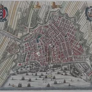 Old maps€500,00
Caspar Commelin (1668 – 1731)
Amsterdam with d’uytlegging van ‘t Jaer 1613 (1693)
-
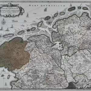 Old maps€350,00
Nicolaes Visscher I (1618 – 1679)
Tabula Frisiae, Groningae et Territorii Emdensis (c. 1660)