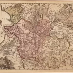
Johann Baptist Homann was a German cartographer, publisher and engraver. In 1702 he established a publishing and trading firm for cartography in Nuremberg, making globes and publishing maps.
Johann Tobias Mayer (1723 – 1762) was a German astronomer, mathematician, cartographer and physicist. This map was originally by Homann and was later republished by Mayer in the atlas Maior Atlas Scholasticus ex Triginta Sex Generalibus et Specialibus.
- Image: map of the 17 United Netherlands with all arms
- year: 1747
- quality: fair, discoloration in the margin that runs slightly into the image on the right side
- signed: in plate
- image size: 48.6 cm x 52.2 cm | 19.1 x 20.6 in (h x w)
- sheet size: 49.8 cm x 60.1 cm | 19.6 x 23.7 in (h x w)
![Tractus regni Angliae septentrion[alis]](https://www.ca-art.nl/wp-content/uploads/2022/04/00329-website-300x300.webp)